Storms in the Gulf of Mexico: What’s Coming Next?
Introduction
The Gulf of Mexico is a well-known hazard zone during the Atlantic hurricane season. Warm waters, swirling atmospheric patterns, and coastal geography make it a prime region for tropical storms and hurricanes. In mid-2025, the region continues to draw attention as sea surface temperatures remain exceptionally warm, and meteorologists warn that another tropical storm could form in the Gulf of Mexico. This article explains how storms form in the Gulf, reviews notable recent storms like Tropical Storm Francine, examines current forecast signals, and offers guidance on how Gulf Coast residents should prepare.
How Tropical Storms Form in the Gulf of Mexico
Warm Waters and Atmospheric Conditions
The formation of tropical storms in the Gulf requires several key ingredients: warm surface waters (typically above 80°F), high humidity in the mid-levels of the atmosphere, and low vertical wind shear. The shallow nature of the Gulf allows sea temperatures to rebound rapidly even after a storm has passed, helping fuel any subsequent systems. Over the years, surface temperatures in the Gulf have warmed at twice the rate of the global average, increasing the odds of more frequent or intense storms Wikipedia.
Climate Drivers and Steering Systems
- Central American Gyre (CAG): A sprawling low-pressure system that often organizes tropical waves and directs them into the Gulf. Notable storms like Hurricane Helene (2024), Michael (2018), and Cristobal (2020) formed under CAG influence Houston Chronicle.
- Bermuda High: A high-pressure ridge that can influence storm tracks. When situated westward, it steers systems toward the Gulf Coast Houston Chronicle.
- El Niño / La Niña: These global conditions influence wind shear across the Atlantic. In neutral to La Niña conditions (as expected in 2025), wind shear is often lower, facilitating storm development Houston Chronicle.
Recent Storm: Tropical Storm Francine
Formation and Path
Francine emerged over the Bay of Campeche on September 9, 2024, originating from a tropical wave that crossed the Yucatán Peninsula. It quickly organized into Tropical Storm Francine, then strengthened into a Category 2 hurricane with peak winds around 100–105 mph. The storm made landfall near Morgan City, Louisiana on September 11 and dissipated by September 14 as it moved inland into Arkansas FOX 13 Tampa Bay+8Wikipedia+8National Weather Service+8.
Impacts
Though no direct fatalities occurred, Francine caused widespread flooding across coastal Louisiana and Mississippi. Rainfall totals ranged from 4 to 12 inches, triggering urban and flash flooding CBS NewsWikipedia. The storm also knocked offline nearly 30% of Gulf oil production and 41% of natural gas output, affecting evacuation protocols and infrastructure Reuters. Overall damage estimates reached about $1.3 billion Wikipedia+1Wikipedia+1.
2025 Storm Season: Outlook and Current Conditions
Above-Average Forecast
NOAA predicts a 60% chance of an above-normal hurricane season, estimating 13–19 named storms, including 6–10 hurricanes and 3–5 major hurricanes. This projection is fueled by unusually warm Gulf and western Atlantic waters as well as favorable wind patterns Houston Chronicle+10expressnews.com+10chron.com+10.
Sea surface temperatures in the Gulf are nearly 2°F above the 1991–2020 average, similar to 2024 conditions that fueled several storms. Experts warn this trend supports stronger storm intensification and more energetic systems Houston Chronicle.
Recent Storms and Monitored Systems
- Tropical Storm Barry (June 28–30, 2025): Originated in the Bay of Campeche, made landfall near Tampico, Mexico, and dissipated over the mountains. Barry caused heavy flooding, resulted in eight deaths, and inflicted nearly $6 million in reported damage. Its remnants later contributed to deadly inland flooding in Central Texas in July, which killed over 130 people Wikipedia.
- Tropical Storm Dexter (August 2025): Formed off the U.S. Southeast coast and moved away from land, posing no threat to the Gulf regions apnews.com+6weather.com+6chron.com+6.
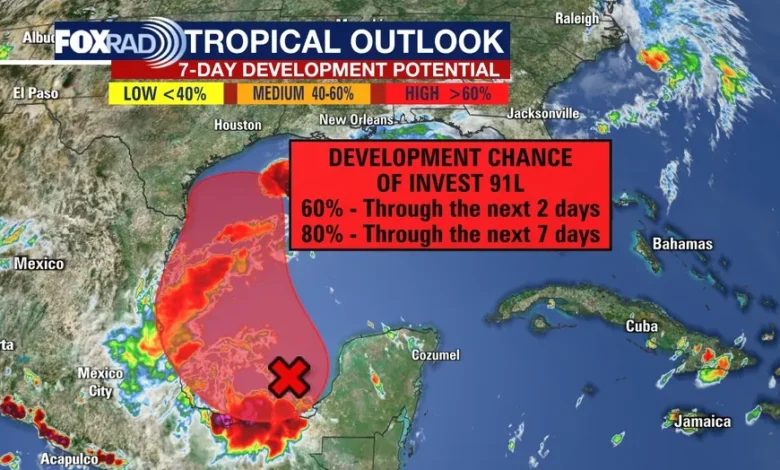
- Other areas to watch: Meteorologists are closely monitoring a low-pressure area off the Southeast U.S. coast (30% chance of development) and a tropical wave from Africa with a medium (40–60%) development chance later this week. Though not immediate Gulf threats, they illustrate rising activity weather.com+3beaumontenterprise.com+3Houston Chronicle+3.
Could Another Tropical Storm Form in the Gulf?
Environmental Signals
With the Gulf season entering its peak (mid‑August through mid‑September), conditions remain favorable: warm waters, low wind shear, and occasional gyre enhancement. Forecast models show potential development in areas currently outside the Gulf, but disturbed systems may enter the basin in coming days Houston Chroniclenoaa.gov.
What “another tropical storm could form in the Gulf” means
The phrase signals early model indications that a system might organize over Gulf waters. Meteorologists base such warnings on probabilities derived from satellite data, atmospheric profiles, and sea temperatures. If conditions align, a disturbance may be upgraded to a Potential Tropical Cyclone, allowing alerts before formal naming. From there, further organization leads to storm naming.
These early warnings help residents and officials prepare even before a system matures.
Why Gulf Storm Preparedness Matters
Texas and Gulf Coast Risk
Texas has a 41% historical chance of a hurricane landfall in any given season—above the national norm. With recent floods and active storm formation patterns, Gulf Coast residents remain at risk for wind, surge, and flash flood damage even from systems that remain just offshore expressnews.comHouston Chronicle.
Critical Steps for Preparation
Local households and municipalities should:
- Finalize evacuation plans and assemble emergency kits.
- Keep critical documents and insurance policies up to date.
- Stay informed via official National Hurricane Center updates and local emergency alerts.
- Monitor weather disturbance outlooks and heed early tropical cyclone alerts.
Energy, maritime, and infrastructure sectors must ensure protocol readiness as well, due to past disruptions from offshore hurricane impacts.
Summary
To summarize:
- The Gulf of Mexico is an active breeding ground for tropical storms during the hurricane season.
- Hurricane Francine (2024) developed in the Gulf, made landfall as a Category 2 storm, and disrupted oil infrastructure while triggering major flooding.
- Tropical Storm Barry (2025) formed earlier this season in the Bay of Campeche, delivering severe flooding in Mexico and contributing to deadly Texas floods.
- Current conditions in mid-2025—unusually warm Gulf waters, reduced wind shear, and ongoing disturbances—point toward ongoing risk.
- Weather models indicate that another tropical storm could form in the Gulf, making vigilance crucial in the coming weeks.
What to Watch in the Coming Weeks
Residents and weather watchers should monitor:
- Updates to the National Hurricane Center’s seven-day tropical outlook.
- Development of disturbances near the southeastern U.S. coast or Central America.
- Changes in sea surface temperatures, wind shear trends, or formation of Central American Gyres.
- Activation of model-based “Potential Tropical Cyclone” alerts.
Even as storms may develop far from land initially, any storm entering the Gulf must be tracked carefully due to rapidly changing conditions.
Final Thoughts
The Gulf of Mexico remains central to Atlantic hurricane activity. With Storms in the Gulf of Mexico becoming more frequent and intense due to warm waters and seasonal patterns, communities must stay prepared. Past storms like Francine and Barry serve as reminders—and mid-season forecasts show elevated risk. If you hear that another tropical storm could form in the Gulf, treat it as a serious alert—not speculation.
Remaining aware, planning ahead, and responding early continue to be the most effective protections in an active 2025 hurricane season. blogvista.co.uk